
 by
by 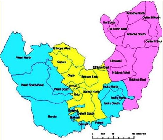
Are you searching for the biggest local governments in Delta State? If the answer to the question is yes, then you’ve landed on the right page. Continue reading!
Delta State, often referred to as the Big Heart of the Niger Delta, is one of Nigeria’s most diverse and dynamic states, boasting a mix of urban centres, riverine communities, and expansive rural areas. The state is administratively divided into 25 Local Government Areas (LGAs), each with its own unique identity and role in local governance and development.
Among these, some local governments cover significantly larger land expanses than others, making them strategic in terms of land usage, resource distribution, and regional influence. Understanding which LGAs have the greatest landmass can give deeper insight into the geographical and administrative landscape of Delta State. In this article, we’ll look at the top 10 biggest local governments in Delta State — ranked based on their actual land area — and explore what makes each of them stand out. From riverine districts to hinterland communities, these LGAs highlight the varied spatial makeup of the state.
So, let’s ride!
Also Check: Properties in Nigeria – Houses, Apartments, Land & Short Lets
How We Ranked the Biggest Local Governments in Delta State
Determining the biggest local governments in Delta State isn’t as simple as looking at popularity or how well-known an area is. Some local governments appear prominent because of their cities or economic activity, while others quietly cover vast stretches of land with dozens of communities spread across them.
To make this list as accurate and fair as possible, we looked closely at how much space each local government actually occupies within the state and how that space is structured. The goal was to reflect real geographical size rather than assumptions.
One major factor considered was how far each local government extends across Delta State. Some LGAs span wide territories that include farmlands, forests, riverine areas, and multiple settlements. These wide boundaries often mean longer travel distances between communities and broader administrative responsibilities.
We also paid attention to the number of towns and villages under each local government. LGAs with many dispersed communities are typically larger in physical size, especially in rural and riverine parts of the state where settlements are spread out over long distances.
Another important consideration was the natural layout of the land. Delta State is known for its mix of rivers, creeks, wetlands, and inland areas. Local governments that stretch across different terrains often occupy more land than those concentrated in urban centres.
Only officially recognized local government boundaries were considered. This helps avoid confusion and ensures that the rankings reflect accepted administrative divisions rather than informal or outdated descriptions.
By using this approach, the list focuses strictly on size and territorial spread. Factors such as population, level of development, or political influence were not used to determine the rankings, as they do not always reflect how large a local government truly is.
With this in mind, let’s take a closer look at the top 10 biggest local governments in Delta State and what makes each of them stand out geographically.
Also Check: Top 10 Largest Local Governments in Edo State by Land Area
Top 10 Biggest Local Governments in Delta State
1. Burutu Local Government Area
Burutu Local Government Area stands out as the biggest local government in Delta State, covering a vast stretch of territory in the riverine part of the state. Located in the southern zone of Delta State, Burutu is largely surrounded by creeks, rivers, and wetlands, giving it a wide and spread-out geographical footprint.
The headquarters of the local government is Burutu town, a historic riverine settlement that once served as an important port during the colonial era. Beyond the headquarters, Burutu LGA consists of numerous riverine communities and islands that are separated by waterways, which naturally contributes to its large physical size.
Fishing, farming, and trading remain major economic activities in the area, with many residents relying on the rich aquatic environment for their livelihoods. Because of its expansive territory and dispersed settlements, Burutu often requires more logistical planning for transportation, administration, and service delivery than smaller LGAs.
Its wide land coverage and riverine nature clearly place Burutu at the top of the list when discussing the biggest local governments in Delta State.
Burutu LGA Overview
- Year Established: 1991
- Location: Southern Delta State (riverine/coastal zone)
- Approx. Area (km²): ~1,937
- Headquarters: Burutu
- Major Towns/Areas: Burutu, Ogulagha, Ogbinbiri, Seimbiri
- Economic Activities: Fishing, farming, local trading, oil-related activities
- Notable Features: Extensive riverine terrain, historic port town, numerous creeks and islands
2. Warri North Local Government Area
Following closely behind is Warri North Local Government Area, one of the most geographically extensive LGAs in Delta State. Warri North occupies a large portion of the western riverine belt of the state and shares boundaries with both inland and coastal areas.
The administrative headquarters of Warri North is Koko, a town known for its port activities and historical relevance in trade. From Koko, the local government stretches across a wide area that includes riverine communities, creeks, mangrove forests, and oil-producing zones.
Warri North is made up of several communities scattered across difficult terrain, which contributes significantly to its large size. The presence of waterways, oil installations, and coastal settlements means the LGA spans a broad and diverse landscape.
In addition to fishing and farming, oil and gas activities play a major role in the local economy. The sheer extent of land and water under its administration makes Warri North one of the largest local governments in Delta State, second only to Burutu in terms of overall coverage.
Warri North LGA Overview
- Year Established: 1991
- Location: Western Delta State (riverine/coastal axis)
- Approx. Area (km²): ~1,841
- Headquarters: Koko
- Major Towns/Areas: Koko, Ogheye, Ebrohimi, Ureju
- Economic Activities: Fishing, oil and gas, trading, marine activities
- Notable Features: Coastal settlements, oil-producing areas, historic port town
Also Check: Top 10 Largest Local Governments in Kaduna State: A Full Breakdown
3. Ndokwa East Local Government Area
Ndokwa East is one of the largest inland local governments in Delta State, covering sprawling tracts of upland forest, farmland, and interconnected rural settlements. It is part of the broader Ndokwa region, which is well known for its cultural heritage and extensive agricultural activities.
As with most LGAs of considerable size, Ndokwa East houses a diversity of towns and villages that are connected by major and minor roads, rivers, and paths. This mixture of transport routes mirrors the varied terrain — part forested, part developed, and part agricultural.
The local economy leans heavily on farming (especially cassava, oil palm, and other staples), local trading, and small‑scale businesses that serve daily community needs. Because of the large number of communities and the geographic stretch it covers, Ndokwa East holds a place among the top 10 biggest local governments in Delta State.
Ndokwa East LGA Overview
- Year Established: 1996
- Location: Northern/central Delta State
- Approx. Area (km²): ~1,617
- Headquarters: Aboh
- Major Towns/Areas: Aboh, Utagba‑Ogbe, Utagba‑Uno, Owa‑Onicha
- Economic Activities: Agriculture, local trade, small‑scale businesses
- Notable Features: Fertile inland terrain, cultural hubs of Ndokwa communities
4. Aniocha South Local Government Area
Aniocha South Local Government Area occupies a significant inland portion of Delta State, characterized by gently rolling landscapes, farmland, and interconnected towns. Unlike riverine LGAs, Aniocha South’s terrain is more accessible by road, with communities that have grown along major transportation routes.
The administrative headquarters is Issele‑Uku, a town known for its traditional institutions and active local markets. Beyond the headquarters, the LGA encompasses many surrounding communities, each contributing to the area’s cultural and economic vitality.
Agriculture plays a major role in everyday life, with many residents engaged in cassava cultivation, palm produce, and other staple crops. Trading and small businesses thrive in market towns, while local festivals and traditions reflect the deep cultural heritage of the Aniocha people.
Aniocha South’s relatively broad land coverage and diverse inland communities make it one of the largest local governments in Delta State.
Aniocha South LGA Overview
- Year Established: 1976
- Location: Central Delta State
- Approx. Area (km²): ~868
- Headquarters: Issele‑Uku
- Major Towns/Areas: Issele‑Uku, Akwu‑Nese, Ebenebe, Ezi, Ubulu‑Uno
- Economic Activities: Farming, trading, services
- Notable Features: Fertile farmlands, strong cultural heritage, market centres
Also Check: Top 10 Largest Local Governments in Adamawa State
5. Ughelli North Local Government Area
Ughelli North Local Government Area is one of Delta State’s prominent inland LGAs, covering a wide territory that encompasses both rural villages and larger community centres. Its spread across upland terrain and established transport routes gives it notable geographical coverage.
The headquarters is Ughoton, a community that serves as the administrative nerve centre for the LGA. From there, Ughelli North extends into settlements known for their economic vibrancy and contributions to both agriculture and local commerce.
Farming remains an essential part of life, with crops such as cassava, plantain, and palm produce cultivated across the region. Cottage industries and small businesses also play important roles in the local economy.
Ughelli North’s expansiveness, combined with its network of communities and economic activities, firmly places it among the top 10 biggest local governments in Delta State.
Ughelli North LGA Overview
- Year Established: 1976
- Location: Central Delta State
- Approx. Area (km²): ~818
- Headquarters: Ughoton
- Major Towns/Areas: Ughoton, Utonlila, Evwreni, Ekakpamre
- Economic Activities: Farming, trading, small industries
- Notable Features: Fertile land, agricultural belt, thriving markets
6. Ndokwa West Local Government Area
Ndokwa West Local Government Area is a vast inland region in Delta State, stretching across fertile farmlands and riverine pockets. Unlike the densely populated urban centres, this LGA is characterized by spacious villages connected through winding roads and waterways, offering a mix of rural charm and agricultural richness.
The LGA headquarters is Kwale, a central hub that anchors administration and commerce for the surrounding communities. The area is known for its dispersed settlements, meaning that traveling from one town to another can reveal varying landscapes — from farmlands to marshy riverine zones.
Agriculture dominates the economy here, with cassava, yams, oil palm, and other crops forming the backbone of daily life. Fishing also supports communities closer to river channels. Traditional festivals and cultural gatherings highlight the rich heritage of the Ndokwa people, making the area culturally vibrant as well as expansive.
Ndokwa West LGA Overview
- Year Established: 1996
- Location: Northern Delta State
- Approx. Area (km²): ~816
- Headquarters: Kwale
- Major Towns/Areas: Kwale, Utagba‑Ogbe, Utagba‑Uno, Onicha‑Olona
- Economic Activities: Agriculture, fishing, local trading
- Notable Features: Fertile farmland, Ndokwa cultural festivals, riverine pockets
Also Check: The Richest Local Government in Cross River State: Top 10 Richest, Economy, and What Makes Them Wealthy
7. Ughelli South Local Government Area
Ughelli South Local Government Area is also considered among the biggest local governments in Delta State.
The LGA offers a different dynamic compared to its northern counterpart, combining residential clusters with stretches of agricultural land. While smaller than Ughelli North, its geographical coverage is still significant enough to make it one of the largest local governments in Delta State.
The headquarters is Ughelli Town, a bustling centre for administration, markets, and social activities. Surrounding the hub are numerous communities, each contributing to the LGA’s economy and cultural life. Roads connect these towns, but the LGA still retains large areas of farmland and undeveloped land, which boosts its overall size.
Farming is the mainstay of the local economy, complemented by small-scale businesses and trade. The area is also known for its peaceful environment and community festivals, reflecting the blend of culture and rural expansiveness that defines Ughelli South.
Ughelli South LGA Overview
- Year Established: 1976
- Location: Central Delta State
- Approx. Area (km²): ~786
- Headquarters: Ughelli Town
- Major Towns/Areas: Ughelli, Eku, Ophorigbala, Ekakpamre
- Economic Activities: Agriculture, trading, small-scale industries
- Notable Features: Large farmland areas, cultural festivals, market hubs
8. Isoko South Local Government Area
Isoko South LGA stretches across the southern central part of Delta State, with a landscape that combines fertile farmland and closely-knit towns. Unlike riverine LGAs, the terrain here is mostly inland, making agriculture the backbone of the local economy.
The administrative headquarters is Ozoro, a town that serves as the political and commercial centre. Surrounding Ozoro are numerous communities, each with distinct cultural identities, yet linked through trade, markets, and communal activities. Roads connecting these towns wind through farmlands and small rivers, highlighting the LGA’s blend of rural and semi-urban features.
Agriculture dominates daily life, with cassava, oil palm, yams, and vegetables cultivated extensively. Local markets, craft trading, and small-scale businesses also thrive, creating a dynamic rural economy. Isoko South’s combination of sprawling settlements and productive land earns it a spot among the biggest local governments in Delta State.
Isoko South LGA Overview
- Year Established: 1991
- Location: Southern-central Delta State
- Approx. Area (km²): ~668
- Headquarters: Ozoro
- Major Towns/Areas: Ozoro, Emevor, Aviara, Oleh
- Economic Activities: Agriculture, trading, small industries
- Notable Features: Fertile farmland, Isoko cultural heritage, local markets
Also Check: The Richest Local Government in Taraba State: Top 5 Richest & Their Economic Powerhouses
9. Warri South West Local Government Area
Warri South West Local Government Area ranks as one of the largest in Delta State, thanks to its combination of expansive water edges, coastal lands, and inland settlements. It stretches from the riverine communities deep into areas where aquatic pathways transition into farmland and uplands, giving it one of the most geographically varied landscapes in the state.
The administrative headquarters of this LGA is Jessie Iredein Street in Ogbe‑Ijoh, but many people simply refer to the area as Warri South West. With communities spread along creeks and river channels, transportation is often water‑based, making travel and logistics unique compared to most inland local governments.
Fishing and maritime trading remain central to everyday life, while small‑scale farming and local markets support the local economy. Additionally, the area is influenced by oil production and related economic activity, due to its proximity to several offshore fields.
Warri South West’s mix of water, land, and coastal settlements, combined with its widespread layout, firmly places it among the biggest local governments in Delta State.
Warri South West LGA Overview
- Year Established: 1996
- Location: Riverine and coastal zones of Western Delta
- Approx. Area (km²): ~633
- Headquarters: Ogbe‑Ijoh (Warri South West)
- Major Towns/Areas: Ogbe‑Ijoh, Otokutu, Esaba, Gbokoda
- Economic Activities: Fishing, marine trading, oil support services
- Notable Features: Mixed waterways and coastal terrain, maritime communities
10. Warri South Local Government Area
Rounding off the list of the top 10 biggest local governments in Delta State is Warri South, a local government that combines urban development with coastal influence. While smaller in land area compared to the top riverine LGAs, its geographical coverage is still substantial, and its coastal positioning adds a unique characteristic.
The headquarters is Warri Town, a major urban and economic hub in Delta State. Beyond the town, Warri South stretches across adjacent communities and stretches toward riverine areas, blending city life with water-adjacent settlements. This mix gives the LGA both strategic and economic significance.
Fishing, commerce, and oil-related activities dominate the economy, while markets and small businesses flourish throughout the LGA. Warri South’s combination of urban settlements, riverine edges, and strategic location makes it an important and expansive local government, completing the top 10 biggest local governments in Delta State.
Warri South LGA Overview
- Year Established: 1991
- Location: Southwestern Delta State
- Approx. Area (km²): ~633
- Headquarters: Warri Town
- Major Towns/Areas: Warri, Aladja, Jakpa, Enerhen
- Economic Activities: Commerce, fishing, oil-related activities
- Notable Features: Urban hub, coastal settlements, strategic economic importance
Also Check: Top 10 Richest Local Governments in Enugu State (Latest Update)
Comparison Table of the Top 10 Biggest Local Governments in Delta State
Below is the comparison table of the top 10 biggest local government in Delta state:
| Rank | Local Government Area | Headquarters | Location in Delta State | Approx. Area (km²) | Major Economic Activities |
|---|---|---|---|---|---|
| 1 | Burutu | Burutu | Southern (Riverine/Coastal) | ~1,937 | Fishing, farming, trading, oil-related activities |
| 2 | Warri North | Koko | Western (Riverine/Coastal) | ~1,841 | Fishing, oil & gas, marine trading |
| 3 | Ndokwa East | Aboh | Northern/Central | ~1,617 | Agriculture, local trade |
| 4 | Aniocha South | Issele-Uku | Central | ~868 | Farming, trading, services |
| 5 | Ughelli North | Ughoton | Central | ~818 | Agriculture, trading, small industries |
| 6 | Ndokwa West | Kwale | Northern | ~816 | Agriculture, fishing, local trading |
| 7 | Ughelli South | Ughelli Town | Central | ~786 | Agriculture, trading, small-scale industries |
| 8 | Isoko South | Ozoro | Southern-Central | ~668 | Agriculture, trading, small industries |
| 9 | Warri South West | Ogbe-Ijoh | Western (Riverine/Coastal) | ~633 | Fishing, marine trading, oil support services |
| 10 | Warri South | Warri Town | Southwestern | ~633 | Commerce, fishing, oil-related activities |
Also Check: Top 10 Richest Local Governments in Plateau State: Discover the Wealthiest Areas Today
Frequently Asked Questions (FAQs)
What is the largest local government in Delta State?
The largest local government in Delta State by land area is Burutu Local Government Area. Located in the southern riverine part of the state, Burutu covers a vast stretch of creeks, wetlands, islands, and coastal communities, making it the most expansive LGA geographically.
List of local governments in Delta State
Delta State has a total of 25 Local Government Areas (LGAs). They include:
- Aniocha North
- Aniocha South
- Bomadi
- Burutu
- Ethiope East
- Ethiope West
- Ika North East
- Ika South
- Isoko North
- Isoko South
- Ndokwa East
- Ndokwa West
- Okpe
- Oshimili North
- Oshimili South
- Patani
- Sapele
- Udu
- Ughelli North
- Ughelli South
- Ukwuani
- Uvwie
- Warri North
- Warri South
- Warri South West
What are the major towns in Delta State?
Some of the major and most well-known towns in Delta State include:
- Warri
- Asaba (state capital)
- Sapele
- Ughelli
- Agbor
- Effurun
- Ozoro
- Oleh
- Kwale
- Oghara
These towns are important due to their population size, economic activities, administrative relevance, or historical significance.
Which tribe is the biggest in Delta State?
The Urhobo ethnic group is the largest tribe in Delta State by population. They are predominantly found in central parts of the state, especially in areas such as Ughelli, Sapele, Okpe, and parts of Warri. Other major ethnic groups in Delta State include the Igbo (Anioma), Ijaw, Isoko, Itsekiri, and Ika people.
What is the nickname of Delta State?
Delta State is popularly known as “The Big Heart of the Nation.”
This nickname reflects the state’s cultural diversity, economic importance, and central role in Nigeria’s oil and gas industry.
Also Check: The Richest Local Government in Kogi State: Top 10 Richest & Key Facts
Top 10 Biggest Local Government in Delta State: Final Thoughts
Delta State’s administrative structure reflects the state’s rich geography, cultural diversity, and economic significance. From vast riverine landscapes to expansive inland farmlands, the biggest local governments in Delta State play important roles in governance, resource management, and regional development. By examining these LGAs based on their physical size, it becomes easier to understand how geography shapes access to infrastructure, economic activities, and public services across the state.
It is important to note that land area figures and rankings are based on commonly referenced and widely accepted data used for general comparison. While every effort has been made to ensure accuracy and clarity, geographical data can sometimes vary slightly across sources due to boundary interpretations or updates.
We welcome feedback from readers. If you notice any corrections, have access to updated information, or believe an LGA has been misrepresented, feel free to share your insights. Your contributions help improve the quality and reliability of this content for everyone.
Overall, this guide aims to provide a clear and informative overview for students, researchers, and anyone interested in understanding the spatial layout of Delta State. As development and administrative structures evolve, these rankings may change, and we remain open to learning and updating this article accordingly.
Join The Discussion