
 by
by 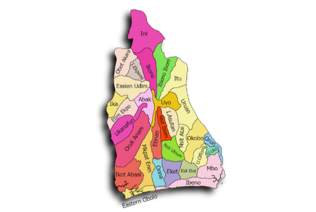
Are you searching for the biggest local governments in Akwa Ibom State? If the answer to the question is yes, then continue reading. You’ve landed right on the page that has everything that you need!
Akwa Ibom State is widely recognized for its expansive landscapes, stretching from inland rural communities to coastal zones along the Atlantic Ocean. As part of its administrative structure, the state is divided into 31 Local Government Areas, each occupying a distinct portion of land and serving as a center for local administration, economic activity, and community life.
Interest in the biggest local governments in Akwa Ibom State continues to grow, especially among students, researchers, investors, and residents who want a clearer picture of how the state is geographically organized. Larger local governments often cover multiple communities, support extensive agricultural activities, and manage broader infrastructure networks compared to smaller LGAs.
This article highlights the top 10 biggest Local Government Areas in Akwa Ibom State, offering a well-researched breakdown of these LGAs and their importance within the state.
By the end of this guide, you will have a clearer understanding of the largest local governments in Akwa Ibom State, why they stand out, and how their size influences development across the state.
Also Check: Properties in Nigeria – Houses, Apartments, Land & Short Lets
What Does “Biggest Local Government” Mean?
When discussing the biggest local governments in Akwa Ibom State, the word “biggest” can be interpreted in different ways depending on context. Some people may assume it refers to population size, level of development, or economic strength. However, in geographical and administrative discussions like this one, biggest has a more specific meaning.
In this article, biggest local government refers strictly to landmass (land area) — that is, the total physical size of a Local Government Area measured by the extent of land it covers. This approach focuses on how wide or expansive an LGA is, not how many people live there or how urbanized it may be.
Land area is an important metric because local governments with larger land coverage often:
- Encompass more towns, villages, and rural settlements
- Support extensive agricultural and natural resource activities
- Face broader infrastructure and administrative responsibilities
- Play strategic roles in regional planning and development
It is also worth noting that a local government can be among the largest in Akwa Ibom State by land area while still having a relatively low population density. Conversely, some smaller LGAs may be more densely populated or economically active despite occupying less physical space.
By using landmass as the defining factor, this ranking provides a clear, objective, and geography-based comparison of the biggest Local Government Areas in Akwa Ibom State, helping readers better understand the state’s spatial and administrative layout.
Also Check: Top 10 Biggest Local Governments in Delta State
Top 10 Biggest Local Governments in Akwa Ibom State
Below are the top 10 biggest local governments in Akwa Ibom State, ranked strictly by landmass (km²). This ranking reflects their physical size and geographic coverage, not population or level of development.
1. Oruk Anam Local Government Area (543.9 km²)
Oruk Anam Local Government Area ranks as the biggest local government in Akwa Ibom State by land area, covering approximately 543.9 square kilometers. It is located in the western part of the state and is widely known for its vast rural landscapes and agricultural potential.
Due to its large landmass, Oruk Anam comprises numerous villages and farming communities spread across a wide territory. Agriculture remains the backbone of the local economy, with large portions of land suitable for crop cultivation such as cassava, yam, oil palm, and maize. The expansive nature of the LGA also means that infrastructure development and service delivery often require extensive planning and resources.
As the largest LGA in Akwa Ibom State, Oruk Anam plays a strategic role in food production, rural settlement expansion, and land-based economic activities within the state.
Overview:
- Year Established: 1989
- Location: Western Akwa Ibom State
- Approx. Area (km²): 543.9
- Headquarters: Nkari
- Major Towns/Areas: Ikot Okoro, Iwot, Ibiaku, Nkwot, Ibesikpo
- Economic Activities: Farming (cassava, yam, oil palm), small-scale trading, animal husbandry
- Notable Features: Largest LGA in the state, extensive farmland, numerous rural communities
2. Okobo Local Government Area (475.8 km²)
Okobo Local Government Area is the second biggest local government in Akwa Ibom State, with an estimated land area of 475.8 square kilometers. It is situated in the south-eastern part of the state, close to coastal and riverine environments.
The large size of Okobo LGA allows it to accommodate a mix of inland and riverine communities. Fishing, farming, and small-scale trading are major economic activities, supported by the area’s natural waterways and fertile land. Its extensive land coverage also contributes to diverse settlement patterns, ranging from clustered towns to sparsely populated rural areas.
Being one of the biggest local governments in Akwa Ibom State by land area, Okobo holds significant importance in coastal economic activities and local resource management.
Overview:
- Year Established: 1989
- Location: South-Eastern Akwa Ibom State
- Approx. Area (km²): 475.8
- Headquarters: Okobo Town
- Major Towns/Areas: Afaha Oku, Esuk, Ikot Ibiok, Etim Ekpo
- Economic Activities: Fishing, farming, trading, canoe building
- Notable Features: Extensive riverine areas, rich in fish resources, mix of coastal and inland communities
Also Check: Top 10 Largest Local Governments in Edo State by Land Area
3. Uruan Local Government Area (449 km²)
Uruan Local Government Area is the third biggest local government in Akwa Ibom State, covering about 449 square kilometers. It is located in the central-southern part of the state, bordering the state capital, Uyo, and is known for its combination of riverine and inland landscapes.
The LGA’s large land area accommodates numerous villages and communities, making it a significant hub for agriculture and local trade. The region is fertile, supporting the cultivation of crops like cassava, yam, oil palm, and vegetables. Additionally, fishing is an important economic activity in areas closer to rivers and streams. Infrastructure development and service delivery are carefully coordinated to manage the spread-out settlements effectively.
Uruan’s strategic location near Uyo also gives it a unique mix of rural charm and proximity to urban facilities, contributing to its social and economic relevance in Akwa Ibom State.
Overview:
- Year Established: 1988
- Location: Central-Southern Akwa Ibom State
- Approx. Area (km²): 449
- Headquarters: Idu
- Major Towns/Areas: Idu, Ata, Ibiaku, Uruan Ibami
- Economic Activities: Farming (cassava, yam, vegetables), fishing, trading
- Notable Features: Mix of inland and riverine areas, proximity to Uyo, fertile agricultural land
4. Ini Local Government Area (406.9 km²)
Ini Local Government Area ranks as the fourth biggest local government in Akwa Ibom State, spanning approximately 406.9 square kilometers. It is located in the eastern part of the state and is characterized by rolling landscapes and fertile soils.
Ini LGA is largely rural, with communities spread across its vast territory. Agriculture dominates the local economy, with large-scale farming of cassava, yam, oil palm, and plantain. The LGA also has small-scale trading hubs and local markets that serve surrounding villages. Its extensive landmass allows for potential infrastructural development and settlement expansion, making it a key LGA in the eastern region of Akwa Ibom State.
The combination of fertile soil, abundant land, and well-distributed communities makes Ini an essential contributor to the state’s agricultural output and rural development.
Overview:
- Year Established: 1989
- Location: Eastern Akwa Ibom State
- Approx. Area (km²): 406.9
- Headquarters: Ikot Ekpene
- Major Towns/Areas: Ikot Ekpene, Ikot Abia, Ikot Akpan
- Economic Activities: Farming (cassava, yam, oil palm, plantain), local trading
- Notable Features: Fertile soil, large agricultural land, key eastern LGA
Also Check: Top 10 Largest Local Governments in Kaduna State: A Full Breakdown
5. Mkpat-Enin Local Government Area (397.2 km²)
Mkpat-Enin Local Government Area is positioned as the fifth largest local government in Akwa Ibom State, occupying approximately 397.2 square kilometers of land. Located in the southern coastal belt, it is characterized by a blend of fertile farmland and access to waterways, making it a vital agricultural and fishing hub.
This LGA’s communities are widely distributed, and the land coverage allows for extensive farming activities, particularly cassava, yam, oil palm, and vegetables. Fishing thrives along its rivers and streams, providing both sustenance and income for local residents. The LGA also hosts small trading centers that connect farmers and fishermen with larger markets across the state.
Mkpat-Enin’s expansive size not only supports productive agriculture and fisheries but also gives room for infrastructural growth, settlement development, and strategic planning for resource management.
Overview:
- Year Established: 1989
- Location: Southern Akwa Ibom State
- Approx. Area (km²): 397.2
- Headquarters: Etinan
- Major Towns/Areas: Etinan, Ikot Abasi, Ikot Akpan
- Economic Activities: Farming (cassava, yam, oil palm), fishing, local trade
- Notable Features: Coastal rivers, fertile farmland, key agricultural LGA
6. Ibiono Ibom Local Government Area (336 km²)
Ibiono Ibom Local Government Area ranks as the sixth biggest local government in Akwa Ibom State, covering around 336 square kilometers. Nestled in the central region of the state, this LGA is renowned for its agricultural richness and wide stretches of fertile land.
The population is distributed among several villages and towns, each contributing to the LGA’s vibrant farming economy. Cassava, yam, and palm produce dominate the agricultural landscape, while small-scale trading serves as a supplementary source of income. Due to its sizeable land area, Ibiono Ibom also presents opportunities for infrastructural development, rural settlement, and natural resource utilization.
Its central location and productive lands make Ibiono Ibom an essential contributor to the state’s overall food supply and rural economy.
Overview:
- Year Established: 1989
- Location: Central Akwa Ibom State
- Approx. Area (km²): 336
- Headquarters: Oko Ita
- Major Towns/Areas: Oko Ita, Obot Akara, Ikot Ekpene
- Economic Activities: Farming (cassava, yam, oil palm), trading, small-scale enterprises
- Notable Features: Fertile central lands, significant agricultural production, wide rural settlements
Also Check: Top 10 Largest Local Governments in Adamawa State
7. Mbo Local Government Area (318.1 km²)
Mbo Local Government Area is also among the biggest local governments in Akwa Ibom State, spanning approximately 318.1 square kilometers. Located along the southern coastline, it is characterized by its riverine communities, mangrove forests, and proximity to the Atlantic, giving it a distinctive coastal identity compared to other LGAs.
The LGA is made up of multiple towns and villages that rely heavily on fishing, aquaculture, and small-scale farming for their livelihoods. The fertile land also supports the cultivation of cassava, plantain, and oil palm. Because of its coastal location, Mbo faces unique challenges in transportation and infrastructure, yet its natural resources make it an important contributor to both the local and state economy.
Mbo’s combination of land and water resources not only supports economic activity but also positions it as a key area for environmental and coastal management initiatives in Akwa Ibom State.
Overview:
- Year Established: 1989
- Location: Southern coastal Akwa Ibom State
- Approx. Area (km²): 318.1
- Headquarters: Mbo Town
- Major Towns/Areas: Atimbo, Ikot Akpa Ntuen, Ikot Abasi, Ikot Edong
- Economic Activities: Fishing, farming (cassava, plantain, oil palm), trading
- Notable Features: Coastal and riverine environment, mangrove areas, fishing communities
8. Essien Udim Local Government Area (298.1 km²)
Essien Udim Local Government Area is as well, ranks among the biggest local governments in Akwa Ibom State, covering roughly 298.1 square kilometers. Situated in the central-eastern part of the state, it is known for its fertile plains and widespread agricultural settlements.
The LGA’s economy is largely agricultural, with cassava, yam, palm oil, and vegetables forming the mainstay of local production. Several towns within Essien Udim serve as commercial centers, facilitating trade and the distribution of produce to neighboring areas. The sizeable landmass also allows for rural settlement expansion and provides space for infrastructural development.
Essien Udim’s mix of agricultural richness and geographic spread makes it a significant player in Akwa Ibom State’s food security and rural development strategies.
Overview:
- Year Established: 1989
- Location: Central-Eastern Akwa Ibom State
- Approx. Area (km²): 298.1
- Headquarters: Urua Inyang
- Major Towns/Areas: Ikot Akpan, Ikot Ntuen, Ikot Ekpene, Ikot Obio
- Economic Activities: Farming (cassava, yam, palm oil, vegetables), trading
- Notable Features: Fertile plains, agricultural production hub, expanding settlements
Also Check: The Richest Local Government in Cross River State: Top 10 Richest, Economy, and What Makes Them Wealthy
9. Ikot Abasi Local Government Area (280.8 km²)
Ikot Abasi Local Government Area covers approximately 280.8 square kilometers, positioning it among the top 10 biggest local governments in Akwa Ibom State. Located in the southeastern part of the state near the Atlantic coastline, it is renowned for its riverine settlements, fishing communities, and historical significance.
The LGA’s economy is anchored on fishing, small-scale farming, and trading. Cassava, oil palm, and plantain are widely cultivated, while the riverine environment supports abundant fish and seafood resources. Its coastal proximity has historically made Ikot Abasi an important point for trade and transport, connecting inland communities to coastal markets.
Despite its smaller land area relative to the largest LGAs, Ikot Abasi remains strategically important for coastal economic activities and resource management in Akwa Ibom State.
Overview:
- Year Established: 1989
- Location: Southeastern coastal Akwa Ibom State
- Approx. Area (km²): 280.8
- Headquarters: Ikot Abasi Town
- Major Towns/Areas: Ikot Abasi, Atan, Ikot Esenam, Ikot Akpan
- Economic Activities: Fishing, farming (cassava, oil palm, plantain), trading
- Notable Features: Coastal and riverine settlements, historical trading hub, access to waterways
10. Ibeno Local Government Area (271.2 km²)
Ibeno LGA rounded up the list of the top 10 biggest local governments in Akwa Ibom State, with about 271.2 square kilometers. The LGA is situated along the southern coastline. It is celebrated for its extensive beaches, riverine areas, and one of Nigeria’s largest oil exploration zones.
It has a combination of inland and coastal settlements. Fishing and aquaculture dominate the economic landscape, complemented by farming activities such as cassava, plantain, and oil palm cultivation. Ibeno’s strategic location along the Atlantic coast has made it a focal point for tourism, oil exploration, and commercial fisheries in the state.
With its unique coastal geography and economic significance, Ibeno is not only among the biggest local governments in Akwa Ibom State but also one of the most strategically important in Akwa Ibom State.
Overview:
- Year Established: 1989
- Location: Southern coastal Akwa Ibom State
- Approx. Area (km²): 271.2
- Headquarters: Upenekang
- Major Towns/Areas: Ibeno Town, Eket, Upenekang, Ikot Abasi
- Economic Activities: Fishing, farming (cassava, plantain, oil palm), oil exploration, tourism
- Notable Features: Extensive coastline, major oil exploration areas, vibrant fishing communities
Also Check: The Richest Local Government in Taraba State: Top 5 Richest & Their Economic Powerhouses
Comparison Table: Top 10 Biggest Local Governments in Akwa Ibom State
Below is the comparison table of the top 10 biggest local governments in Akwa Ibom State:
| Rank | LGA Name | Approx. Area (km²) | Headquarters | Major Towns/Areas | Economic Activities | Notable Features |
|---|---|---|---|---|---|---|
| 1 | Oruk Anam | 543.9 | Nkari | Ikot Okoro, Iwot, Ibiaku, Nkwot, Ibesikpo | Farming (cassava, yam, oil palm), trading, animal husbandry | Largest LGA in the state, extensive farmland |
| 2 | Okobo | 475.8 | Okobo Town | Afaha Oku, Esuk, Ikot Ibiok, Etim Ekpo | Fishing, farming, trading | Coastal and inland mix, rich in fish resources |
| 3 | Uruan | 449 | Idu | Idu, Ata, Ibiaku, Uruan Ibami | Farming (cassava, yam, vegetables), fishing, trading | Mix of riverine and inland areas, fertile land |
| 4 | Ini | 406.9 | Ikot Ekpene | Ikot Ekpene, Ikot Abia, Ikot Akpan | Farming (cassava, yam, oil palm, plantain), trading | Fertile soil, key eastern LGA |
| 5 | Mkpat-Enin | 397.2 | Etinan | Etinan, Ikot Abasi, Ikot Akpan | Farming (cassava, yam, oil palm), fishing, trade | Coastal rivers, fertile farmland |
| 6 | Ibiono Ibom | 336 | Oko Ita | Oko Ita, Obot Akara, Ikot Ekpene | Farming (cassava, yam, oil palm), trading | Fertile central lands, wide rural settlements |
| 7 | Mbo | 318.1 | Mbo Town | Atimbo, Ikot Akpa Ntuen, Ikot Abasi, Ikot Edong | Fishing, farming, trading | Coastal and riverine environment, mangroves |
| 8 | Essien Udim | 298.1 | Urua Inyang | Ikot Akpan, Ikot Ntuen, Ikot Ekpene, Ikot Obio | Farming (cassava, yam, palm oil, vegetables), trading | Fertile plains, agricultural hub |
| 9 | Ikot Abasi | 280.8 | Ikot Abasi Town | Ikot Abasi, Atan, Ikot Esenam, Ikot Akpan | Fishing, farming (cassava, oil palm, plantain), trading | Coastal/riverine settlements, historical trading hub |
| 10 | Ibeno | 271.2 | Upenekang | Ibeno Town, Eket, Upenekang, Ikot Abasi | Fishing, farming (cassava, plantain, oil palm), oil exploration, tourism | Extensive coastline, major oil exploration areas |
Also Check: Top 10 Richest Local Governments in Enugu State (Latest Update)
Frequently Asked Questions (FAQs)
1. How many Local Government Areas are in Akwa Ibom State?
Akwa Ibom State is divided into 31 Local Government Areas (LGAs). Each LGA serves as an administrative unit responsible for local governance, development planning, and community services. These LGAs vary in size, population, and economic activities across the state.
2. What is the biggest Local Government in Akwa Ibom State?
The biggest Local Government in Akwa Ibom State by land area is Oruk Anam, covering approximately 543.9 km². It is located in the western part of the state and is known for its extensive farmland, numerous villages, and significant agricultural output.
3. What is the smallest Local Government in Akwa Ibom State?
The smallest Local Government in Akwa Ibom State is Onna, with a land area of 47.41 km². Despite its smaller size, Onna is a vibrant LGA with active farming, local trading, and a close-knit community structure.
4. What is the second largest city in Akwa Ibom State?
The second largest city in Akwa Ibom State is Eket, following Uyo, the state capital. Eket is a major commercial and industrial hub, particularly noted for oil exploration, refining, and associated businesses, contributing significantly to the state’s economy.
5. What is the largest tribe in Akwa Ibom?
The Ibibio are the largest ethnic group in Akwa Ibom State. They are predominantly found in the central and southern parts of the state and are known for their rich cultural heritage, language, and traditional practices. Other notable tribes include the Annang, Oron, and Eket.
6. What are the major towns in Akwa Ibom State?
Some of the major towns in Akwa Ibom State include:
- Uyo – the state capital and administrative center
- Eket – industrial and oil hub
- Ikot Ekpene – historic trading town
- Abak – known for agriculture
- Ikot Abasi – riverine and coastal town
- Ibeno – coastal and tourism area
These towns serve as economic, administrative, and cultural centers across the state.
7. What is the most beautiful Local Government in Akwa Ibom State?
Beauty is subjective, but many consider Ibeno Local Government Area to be the most beautiful in Akwa Ibom State. It boasts extensive beaches, riverine landscapes, and coastal scenery, making it a popular spot for tourism and leisure. Other visually appealing LGAs include Mbo and Okobo, known for their natural waterways and mangrove forests.
Also Check: Top 10 Richest Local Governments in Plateau State: Discover the Wealthiest Areas Today
Top 10 Biggest Local Governments in Akwa Ibom State: Final Thoughts
Exploring the biggest Local Governments in Akwa Ibom State provides valuable insight into the state’s geography, administrative setup, and economic potential. From Oruk Anam, the largest LGA with vast farmland and multiple communities, to Ibeno, a coastal LGA rich in natural beauty and economic activities, each area contributes uniquely to the development and identity of Akwa Ibom State.
Understanding the land area of these LGAs helps highlight the diversity of settlement patterns, infrastructure needs, and resource management across the state. Larger LGAs often face challenges in service delivery due to their size, yet they also offer greater opportunities for agriculture, fisheries, and rural development.
While this guide focuses on land area, it’s important to recognize that other factors—such as population, culture, and economic activity—also shape the significance of each LGA. We encourage readers to explore these LGAs personally or conduct further research to appreciate their unique characteristics fully.
By highlighting the top 10 biggest Local Governments in Akwa Ibom State, this article aims to provide accurate, well-researched information for students, researchers, investors, and residents who want a clear understanding of the state’s largest administrative regions.
Whether you are studying geography, planning to invest in agriculture or tourism, or simply curious about Akwa Ibom’s administrative structure, knowing the biggest LGAs by land area is an essential starting point.
What do you have to say about this piece of information? We are upon for any opinion, recommendations, or adjustments. Thanks.

Join The Discussion